Where travel agents earn, learn and save!

No data found
Travel & Selling Tips / Here's what you want to know about hiking the Arizona Trail
The Arizona National Scenic Trail is a continuous footpath that runs roughly 800 miles from the Mexican border
The Arizona National Scenic Trail is a continuous footpath that runs roughly 800 miles from the Mexican border all the way across the state until reaching the Stateline Campground in Utah. The trail weaves through the Sonoran Desert and a selection of appropriately named “sky islands,” stretches of towering mountain ranges that boast pine forests, cool weather and even snow (a vast contrast to the harsh desert below).
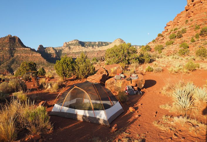
The trail then works its way through some of Arizona’s most stunning mountain scenery, from the Superstition Wilderness to the Four Peaks and Mazatzal Mountains, before climbing up onto the Mogollon Rim. The AZT then makes a dramatic finish, crossing the Grand Canyon and descending the Kaibab Plateau into the red rock canyon landscape that marks the end of the route at the Utah border.
It takes about six to seven weeks to hike the entire Arizona Trail, with thru-hikers usually attempting the route either in spring or fall, so as to avoid the weather extremes that are encountered along the way, and to maximize water source availability.
In the spring, hikers head north, and in the fall, they go southbound. While long-distance hikers have resupply plans (the trail runs through gateway communities along or near the route roughly every 4-6 days), physical preparation and need a good water plan, those not quite as ambitious can opt for section hiking any one of the trail’s 43 passages, doable in a day or weekend, and spaced out over time.
While some 400 hikers finish the entire trail each year, the vast wilderness spaces marking each passage ensure that the AZT can be a very solitary experience. When my wife and I hiked the full trail in spring of 2021, other than a handful of nights camping next to others, we spent most of our time being surrounded more by elk, rattlesnakes and cacti, rather than human beings.

The AZT is nowhere near as popular as the larger long-distance trails, such as the Appalachian Trail or Pacific Crest Trail. While those trails are far longer, most of those who’ve completed these marathons say that the AZT is by far more challenging, mostly due to its combination of rugged terrain, water worries and extremes of environment.
The Arizona Trail passes through the ancestral lands of Native Americans, who have traveled and lived across these passages for thousands of years, but the modern trail was the brainchild of a Flagstaff school teacher. Dale Shewalter first envisioned a cross-state trail in the 1970s, and spent the next two decades trying to get established trails connected and new trails built, while bringing together trail users and governmental agencies into a trail community.
In the 1990s, the non-profit Arizona Trail Association became the official voice of the trail, and their website boasts a wealth of information on everything from maps to water reports to a list of gateway communities and services, and all else that is needed to hike any portions of the AZT.
Most people envision Arizona as a lot of hot desert, but the AZT reveals just how varied and extremely diverse the state is. Most of the lower desert hiking, from down on the border near Sierra Vista all the way up to the Superstition Mountains northeast of Phoenix, needs to be done from October through April. Yet, scattered through here are areas such as the Huachuca, Santa Catalina and Santa Rita mountains, where December through February sees snow, and any drop in spring or fall temps can bring flurries.
In fact, the trail passes through the community of Summerhaven on Mount Lemmon, southern Arizona’s only ski resort and the spot where Tucsonans go to escape the city heat in the summer. Further north, if you arrive too early on the Mogollon Rim, a high-altitude plateau above 6,000 to 7,000 feet, you’ll be walking in snow.
Then, the Grand Canyon produces its own weather challenges, as the North Rim doesn’t officially open until May 15, while the Canyon’s inner gorges see 100-degree temps as the norm by mid-May.
No permits are required to hike the Arizona Trail, other than camping permits needed to stay overnight in both Saguaro National Park and the Grand Canyon. One benefit for those thru-hiking is that one doesn’t have to apply for a Grand Canyon permit months in advance. Rather, AZT hikers are given an exception and able to secure overnight permits at Bright Angel or Cottonwood down in the heart of the canyon.

So if you’re looking for a place to escape the crowds this year, commune with nature, challenge your hiking skills and see the best of one of the western U.S. states, head for the Arizona Trail. The AZT promises you’ll get familiar with more than 50 species of cactus found in the Arizona desert, see sunsets you’ll never forget, savor an adventure and make memories you will treasure long after your trek is over.
More Selling & Travel Tips:
Palmaia – The House of AiA: Wellness Where the Jungle Meets the Sea
Palmaia – The House of AiA presents the Architects of Life program
Travel with Confidence to AMResorts properties!
Caribbean Destination Wedding Experience at Be Live Hotels in the Dominican Republic